|

| Difficulty: |
Hard |
| Distance: |
145km, 90 miles |
| Parking: |
Ample |
| Waymarker: |
Gull on blue sign |
About the Road of the Gull
This trail has a rugged path which circles the whole island. Called
Raad ny Foillan in Manx, it offers excellent cliff top views and coastal
walks. The trail was created to mark the Heritage Year Celebrations in 1986.
The trail is broken up into sections as it is very long. Best to
access the different sections of the trail at points near populated areas
which are easily to reach by public transportation or car.
Route Plan
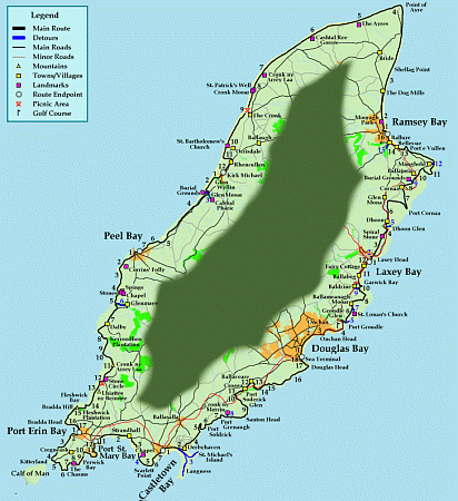 Click for full size image
Walking the Road of the Gull
Start 1 - Douglas
- Starting at the far end of the promenade, near the
Sea Terminal Building
follow along the bay as it curves away from the
Tower of Refuge.
- At the far end of the Promenade the trail comes to Derby Castle and
the start of the Manx Electric Railway.
- Following the railway line up the hill to Onchan Head. The trail
leads away from the railway to follow the coast and then joins
the railway line again briefly as it curves around Onchan Harbour.
- Continuing past the harbour and along the coast for awhile, only to
meet up again with the railway line as the trail goes around the side
of King Edward Bay Golf Course.
- Now entering Groudle, detour here to venture down into the
Groudle Glen
or take a ride on the Groudle Glen
Railway to Sea Lion Cove (check times).
- Continuing back on the trail as it heads once more for the coast over
looking Port Groudle, then heads inland and joining a road.
- Along the road is a detour by footpath to
Lonan Church with its many ancient crosses.
- The road and trail moves on to Ballameanagh Mooar and slightly past
it turns right moving off the road and into the countryside.
- Once the trail joins again with a road, Baldrine is not far off. Detour
to this village for refreshments or to visit the two historical sites
of Cronk ny Fannag or a cloven stone burial.
- The trail moves away from the road before reaching Baldrine and heads
for the coast overlooking Garwick Bay.
- Leaving the views of the bay and turning back inland, the trail meets
up again with the Manx Electric Railway
and follows along it (mostly) to Ballabeg and then on to Fairy Cottage.
- Just before Fairy Cottage the trail turns right and heads across the
railway line and down to Laxey Bay.
Start 2 - Laxey
- Following along the bay to Laxey Harbour and
then moving inland and
along a road for a short distance before once again moving off into
the countryside.
- Detour slightly here to look at St Nicholas Chapel before moving up
Laxey Head.
- The trail now climbs Laxey Head and joins another road. Following
this road and the trail will take you past a inscribed stone site.
- Continuing on the road till the trail moves off the road to the right and
passes over the railway lines.
- Near Dhoon Glen now, where a detour to
visit this beautiful glen is well worth the time.
- The trail now passes Dhoon, following the railway line and then
breaking right and moving along another road towards Glen Mona.
- Around Glen Mona the trail heads in the direction of the coast, near
Port Cornaa. The road ends and the trail moves again inland.
- Crossing over the Manx Electric Railway
line. The trail once more joins the road heading to Maughold.
- Detour near Short Horned Cairn for Ruillic ny Quakeryn burial grounds.
- Following the road past Ballajora, where the road crosses the railway
line. Continue on to Maughold till the trail turns off right onto
another road heading for the coast.
- The trail moves along the coast and then back inland to Maughold.
- Detour to visit Maughold Church, where
most of the Island's ancient
crosses were found near. Another slight detour is on to St Maughold's
Well.
- Carrying on along the coast the trail comes to Port e Vullen. A brief
time on the road and then down along the coast, which is only accessible
at "low" tide. If the tide is high, then do not leave the road, but
carry on till the trail rejoins further along.
- The road will now cross the railway line at Bellevue and then continue
on to Ballure.
- Detour from the trail to visit Ballure with its many footpaths.
- The trail now moves down into the Ramsey Bay
and follows along the coast to the harbour.
Start 3 - Ramsey
- Following the harbour to the bridge, cross over the Sulby River and
continue along the coast.
- The trail passes Mooragh park on its left
and continue along the coast of the flat northern plain.
- Pass the Dog Mills and then on to Shellag Point. This part of the
trail covers a lot of miles and natural beauty, but little else.
- The next marker will be Point of Ayre and its lighthouse. This being
the Isle of Man's top point before heading south along the west side
of the Island.
- The trail moves on to "The Ayres" with its visitor centre. Another
site worth viewing before continuing along between it and the coast.
- Moving right along the side of the coast, pass by Cashal Ree Gorree.
- Next pass Tumulus, Cronk ny Arrey Laa.
- Further south along the coast is St Patrick's Well. and Tumulus, Cronk
Mooar.
- Near "The Cronk" the trail passes a parking and picnic area before
continuing to head along the quiet coast.
- The trail will pass St. Bartholonew's Chapel, near Orrisdale.
- Nearing Kirk Michael, the trail heads inland by Glen Trunk and through
Ballarhenny Beg.
- Continuing on to Rhencullen the trail joins an old railway line heading
south into the village of Kirk Michael.
Start 4 - Kirk Michael
- The trail passes through Kirk Michael going south by the old railway
line to Glen Wyllin.
- Continuing along the old railway line, the trail comes to
Glen Mooar.
- Detour here heading towards the coast, where two burial grounds are
located or head inland to an old chapel, Cabbal Pharic.
- Follow the old railway line south as it moves along the coast
passing over Glion Cam and later Glion Broigh before heading
inland again.
- The trail carries along inland till it reaches a main road. Here it
turns right and continues south along the road.
- After a short time on the road the trail turns right and back out to the
coast.
- Following tight to the coast, the trail leads down into
Peel Bay and along the promenade.
Start 5 - Peel
- The trail moves along the side of the Peel harbour
and across the bridge.
- Climbing up the hill to the coast once more and along it past
Corrin's Folly.
- The trail moves inland slightly before once again moving out to follow
the coast.
- Continuing on for about a mile. Inland there are a few sites of interest
which might be worth detouring to see. They include, an old chapel,
stones, and springs.
- Follow the trail along the coast and as it moves inland to
Glen Maye.
- Detour here to see the beautiful Glen Maye.
- The trail continues inland and then along the main road to Dalby.
- Shortly after Dalby, the trail moves right and off the main road towards
Kerrowdhoo Plantation.
- Following beside Manx National Trust land moving closer to the coast.
- Over the Glion Mooar and now back inland moving right through Manx National
Trust land.
- Moving off trust land now and into public rambling. Climbing the hill
brings the trail past Cronk ny Arrey Laa before heading down hill again.
- The trail passes by a stone circle site on its left and just afterwards
a picnic area with parking.
- Moving up hill again take the trail by Lhiattee ny Beinee and along
a plateau.
- Follow the trail downhill and towards the coast over Fleshwick Bay.
- Moving inland the trail passes through Fleshwick Plantation and on to
Bradda Hill.
- The trail heads to the coast again and passing along it shows the
coastguard look out and Milner's Tower which sit close together on
Bradda Head.
- Continue to follow along the coast as it drops down and into
Port Erin and runs along the promenade.
Start 6 - Port Erin
- The trail follows along the promenade and round past the lighthouse.
- Moving around the the headland out of Port Erin, the trail passes by the
Marine Biological Station and Aquarium.
- Continuing on along the coast, soon the Calf of Man will be visible
in and distances with the trail moving towards it.
- Coming now to a parking area at the sound of man looking over Kitterland
(rocks) and behind it the Calf of Man.
- The trail follows close to the coast, passing an ancient earthwork site
and shortly after a promontory fort.
- Following the trail now leads it through Manx National Trust land, though
still following near the coast.
- The Chasms now come into view as the trail moves slightly inland to avoid
the area.
- Following around the Chasms the trail moves slightly towards the coast
and the Sugarloaf (rock formation), where many birds nest.
- The trail now moves inland slightly and joins a road heading to
Port St Mary. The trail follows this
road for a short while and then breaks off to head along the coast.
- Moving past Perwick Bay on the right, passing Shag Rock and then Flat Rock
sitting close to the coast in the waters below.
- Moving around this headland soon reveals
Port St Mary.
- Following along the coast and on into
Port St Mary Bay continue past the harbour and up to Chapel Bay.
Start 7 - Port St Mary
- Heading along Chapel Bay the trail moves around a small headland and
joins a road following the coast of Bay ny Carrickey.
- Passing by Strandhall and still following tight to the coast.
- The trail nears a chapel site on the left and then passes a earthworks
on the right.
- Near the earthworks there is a short detour to see the St Bartholomew's
Chapel.
- Continue on along the coast past the burial grounds on the left and on
to the Stack (rock formation) and Scarlett Point.
- The trail moves around the headland and passes by the Scarlett Visitor
Centre.
- Following along the coast of Castletown Bay the trail leads into
Castletown, passing by
Castle Rushen and over the Harbour.
Start 8 - Castletown
- Crossing over the Castletown harbour the
trail continues along the coast of Castletown
Bay.
- Pass the remains of a summer house on the right and on to Derbyhaven.
- Detour here to visit Langness and St Michael's Island.
- Continuing on near Ronaldsburn and past the 1275 battle site of
Ronaldsway.
- The trail follows the coast up to where the Santon Burn flows into the sea.
Here the trail moves inland to follow around the ravine.
- Moving along the coast the trail rounds Port Soldrick and continues
on close to the sea.
- Following the coast to Port Grenaugh, where the trail moves along
the coast overlooking the sheltered beach.
- Detour here to visit Cronk ny Merriu.
- The trail continues along the coast of Santon Head, passing an Earthwork
site on the right and shortly after heading inland.
- Moving directly inland now, the trail crosses over the
Steam Railway line following a road to
its end.
- The trail turns right and follows another road towards Crogga.
- Passing Crogga the trail heads on to Ballaveare, turning right onto
another road leading to Port Soderick.
- Follow the trail over the Steam Railway
line and into Port Soderick Glen.
- The trail moves straight through
Port Soderick Glen and to the coast
where it follows along the promenade and up the hill.
- Soon the trail meets a road and follows along it a way before moving
off to the right and towards Marine Drive.
- When the trail turns into more of a road, Marine Drive has been reached.
It leads around Douglas Head, past the
lighthouse and Harold Tower.
- The trail runs on a road now, down into Douglas
overlooking Douglas Bay.
- When the harbour is reached, cross over the first bridge and continue
along the road to the coast and Sea Terminal.
Related News Articles
- Runway Extension Study 24 June 2004
The lsle of Man Government have approved a detailed feasibility study into extending the main runway at Ronaldsway. [More]
| Publications |

|
Walking on the Isle of Man: 40 Walks Around the Island (Cicerone British Walking)
Terry Marsh
Cicerone Press, Paperback, 12 April, 2006
ISBN: 1852843993
List Price: £10.00
New Price: £8.09
Used Price: £4.49
Third Party Price: £4.49
Buy Now
More Info
|

|
The Isle of Man Coastal Path: Raad Ny Foillan - The Way of the Gull - The Millenium and Herring Ways (British Long-distance Trails)
Aileen Evans
Cicerone Press, Paperback, 30 June, 2004
ISBN: 1852844000
List Price: £10.00
New Price: £9.49
Used Price: £4.49
Third Party Price: £4.49
Buy Now
More Info
|
|
|
|


