| Difficulty: |
Easy |
| Distance: |
40km, 25 miles |
| Parking: |
Ample |
| Waymarker: |
Green circle with a three leg swirl in the middle |
About the Millennium Way Trail
The first long distance footpath it was established in 1979 to celebrate
the Millennium year of the Manx Parliament, Tynwald. The path links Ramsey
to Castletown, following the way of past Manx Kings through the centre
of the island. The route was once known as the Royal Way and is
recorded in the 13th Century Chronicles of the Kings of Mann and the Isles.
It is known as an early highway with a long and old history.
This route can be covered in a day by an experienced walker, but for those
not up to the challenge the trail can be broken down into three bits. These
sections can be easily reached by public transportation or car.
Route Plan
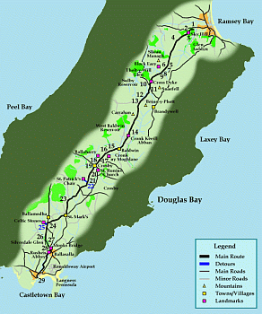 Click for full size image
Walking the Millennium Way Trail
- This trail starts one mile from Ramsey on the
main road to Kirk Michael.
- Climb up Sky Hill (The site where Norse King Godred Crovan conquered
the Manx in 1079.) where there are views of Milntown and the Albert Tower.
- The hill is pretty steep, but at the top views of
Ramsey and the flat
northern plain where Jurby Church and the lighthouse of Point of Ayre
can be seen.
- Now follow an old road through the open moorland of North Barrule.
- The trail now moves to the right and onto the Mountain Road.
- Pass over the slope of Slieau Managh to over look the
Block Eairy and Sulby Reservoirs.
- Moving down now to a stream with Snaefell overhead. Here lie many
mounds which were long ago homes for people who pastured there animals
on the mountain in the summer.
- Cross the boundary fence by the stile.
- Follow the waymarkers to the ford of the river and cross by the
stepping stones.
- Climb the slope of Snaefell for a short way following the waymarkers
and join the Tholt-y-Will Road near the Cross Dyke at Cleigh Yn
Arragh.
- The way now leads through a valley to Beinn-y-Phott. Pass by the
old mine works left in 1867.
- Follow the Stream bed to join the old Royal Way.
- Cross the Brandywell Road and pass between Beinn-y-Phott and Carrahan.
See Douglas and the south with the Langness peninsula in the far distance.
- Descend now into West Baldwin. Passing Cronk Keeill Abban, an old
site for the outside assembly of Tynwald. St Luke's Chapel is also
along the trail.
- At West Baldwin bridge the way enters the parish of Marown.
The trail diverts from the Royal Way now to pass between
Cronk ny Moghlane and Ballaharry farm.
- The way now descends into Crosby and past Ballayemmy.
- Pass the remains of the Chapel of St Brigit, which sits along with much
of its surrounding on land once given to the Priory of Whithorn in
Galloway by King Olaf 11 (great grandson of Godred Crovan).
- The way now moved down into Crosby Village and past Eyreton Farm.
- Cross over the Douglas to Peel Road and climb School Hill, which was
named after the old Marown School sitting at the top of the hill.
- Moving on past the school, now coming to the small church of St Runius.
The church dates back to the 12th century and is work a visit.
- The way now conquered on roads for a few miles.
- As you pass under some Oak trees, there is a detour to visit St Patrick's
Chair (a small group of standing stones). Named after St Patrick as
some believed he use to preach from the spot. Backtrack to rejoin
the way.
- The way now carries on to the church of St Marks in Malew. The
houses adjoining the old church school were built to provide income
for educating expenses. The site is worth viewing.
- The way joins the road at Ballamodha and passes some Celtic remains.
- Detour slightly to see the Celtic remains (grey stones), before
continuing on the way.
- Further along the main road and down a wooded hill, the way meets the
Silverburn River and heads into Silverdale
Glen.
- Passing by a disused mill dam now used as a boating pool, the way has
come to Silverdale.
- Continuing beside the river, the way comes to
Monks Bridge and nears
Rushen Abbey before moving out of
Ballasalla.
- The way follows along Silverburn now and into
Castletown where it ends at the Harbour near Castle Rushen.
| Publications |

|
Walking on the Isle of Man: 40 Walks Around the Island (Cicerone British Walking)
Terry Marsh
Cicerone Press, Paperback, 12 April, 2006
ISBN: 1852843993
List Price: £10.00
New Price: £8.09
Used Price: £4.49
Third Party Price: £4.49
Buy Now
More Info
|
|


