
Monday, December 15, 2025
|
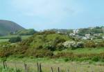
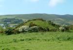
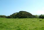
You are here: Isle of Man > Attractions > Early Historical Sites > Promontory Forts HistoryAlso known as Fairy Hill, the site shows a possible artificial hill with remains of a stone faced structure on the top, typical of a motte or castle mound. Around 35 ft high with a ditch around the base. Possibly one of the timber forts constructed around 11AD. Excavated in the early 1900's.LocationNear Port Erin in the south of the Island.Map Ref: SC 205 698 By Vehicle: Locate the A7 in the south of the Island. Take the A5 from Douglas or A27 from Peel. The site is near Ballachurry overlooking the Rowany Golf Course. By Bus: Take the no. 1 or 2 bus from Douglas, or no. 8 from Peel. Walk to the site along A7 through Port Erin towards Ballachurry, about half a mile away. By Railway: Take the Electric Railway to Douglas and then the Steam Railway to Port Erin. Walk to the site along A7 through Port Erin towards Ballachurry, about half a mile away. |
   |
|
Other Guides by Maxima Systems Ltd: Disney World